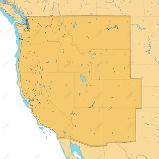
SHADED RELIEF: Bring the world around you to life, with 3D rendered land and underwater elevation – including areas of Ultra-High-Res Bathymetric imagery – a game-changer for anglers and divers.
FULL-FEATURED VECTOR CHARTS: Making navigation easy by giving you accurate, up-to-date vector chart detail derived from official Hydrographic Office information.
HIGH-RES BATHY: Helps you identify shallow areas, drop-offs, ledges, holes or humps. Now includes compiled and quality-controlled Genesis detail as part of singular HRB layer.
CUSTOM DEPTH SHADING: Set a clear safety depth, maintain a paper-like view or create your own custom shading.
EASY ROUTING: Helps you automatically plot the shortest, safest route based on detailed chart data and your personalized vessel information. No subscription required.
Lowrance M-NA-Y211-MS C-MAP Reveal US Lakes West
Product details
ASIN
B08RQR71Y5
Marketplace
🇺🇸 US · USD
Category
Amazon
Best Sellers Rank
#25
Customer reviews
336 ratings · 4.2/5
Delivery
Fast Prime-eligible delivery
Returns
30-day free returns
$0.00
FREE delivery for Prime members
Returns allowed within 30 days
Shipped & sold by Amazon